home
***
CD-ROM
|
disk
|
FTP
|
other
***
search
/
Maxon PD Collection 2
/
Maxon Compact Disc 2.zip
/
Maxon Compact Disc 2.iso
/
pd_base
/
pd_stc
/
751_800
/
762_4.img
(
.png
)
< prev
next >
GEM Raster Bitmap
|
1995-06-29
|
15KB
|
640x400
|
1-bit (2 colors)
Labels:
bulletin board
|
reckoner
|
sky
|
tree
|
window
OCR:
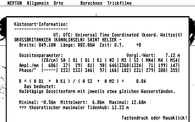
HEPTUN Allgemein Orte Berechnen Trickfilme Kustenort-Ioformation UT UTC : Universal Tine Coordinated (koord. Weltzeit) GROSSBRITANNIEN (KANALINSELN) SAINT HELIER Breite 849.10N Lange 002 M90 Zeit U.f Gezeitenparameter Verg1 -Wert 7.12 Iz0/cm1 Q1 I 01 l I K1 I N2 M2 S2 MN4l M4 MS4 Amp1. /nm 6061 29 81 901 711 1991 147 Phase/ 2231 233| 3461 971 1661 1821 2311 2791 3001 3551 01 A K1 0.04 Das bedeutet Halbtagige Gezeitenform mit jeweils etwa gleichen Wasserstanden. Minimal: 56m Mittelwert: 06m Maximal: 12. 68m theoretischer maximaler Tidenhub 13.23 Tastendruck oder Mausklick! NEPTUN Information Time Geze tenpar ameter Verg 646133601 11324 279j Gezei tenform Wasser standen Mininal Mausk lick